autumn on the west coast of Victoria can bring gales and wild seas one day and blue skies, calm seas and clean swell the next. I took the following photos along the coast between Apollo Bay and Peterborough on successive days as autumn was drawing to a close, and on the first day of winter. While the sky was blue at times, winter was in the air.
Bodysurfing at Apollo Bay in the final days of autumn
This shot was taken during a bodysurfing session with Richard in the waves at Tuxion beach 300m from my front door in Apollo Bay. Richard stroking smoothly into a wave which he caught to the shore. Neither of us wore fins. Body-surfing is a joy. It’s also an art.
The Twelve Apostles and Gibson Steps
A less common view of the Twelve Apostles. This shot was taken from a distance of 11kms. Late afternoon sea mist moved in and completely obscured Gibson Steps.The Great Ocean Road just west of the Gibson Steps car park. The coast just west of Gibson Steps in moody late afternoon sea fog.
Big wave site with only one surfer out
Conditions were not ideal with a cross wind blowing, but they were good enough for this surfer to tow into this wave which I’m sure left him feeling that his drive to the location was worth the effort. While this site can hold considerably larger waves than the one shown, this is not a small wave.
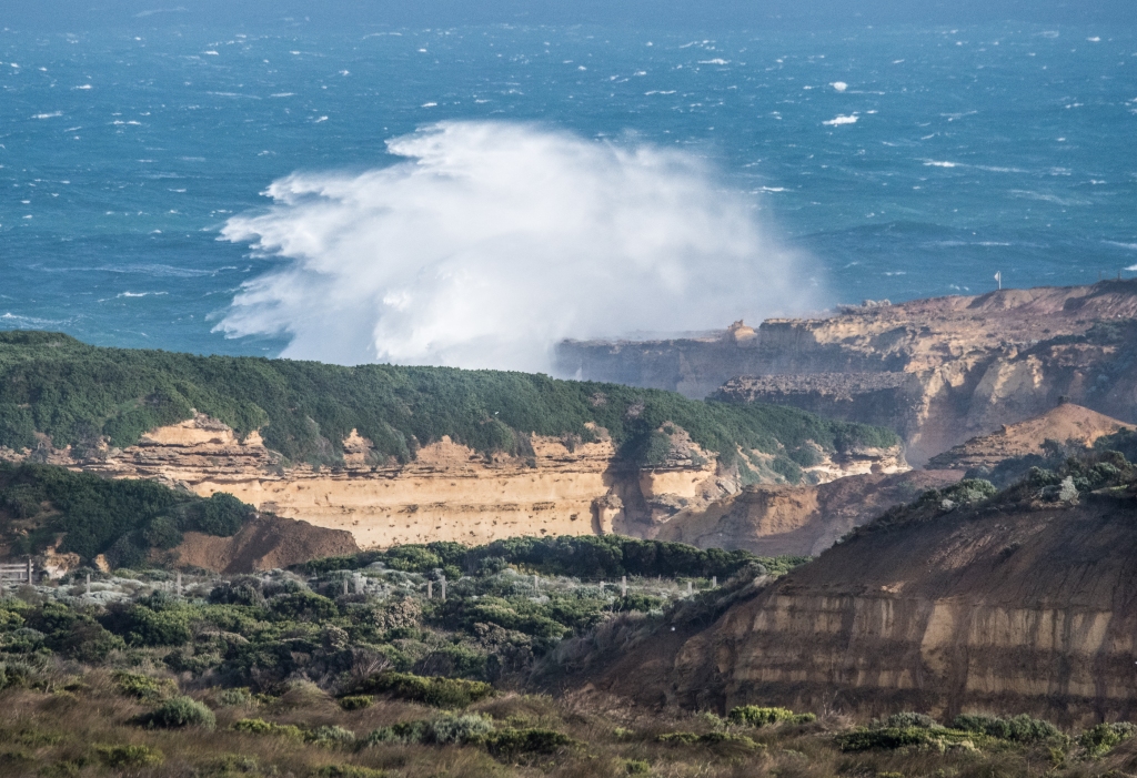
TheSouthern Ocean continues its work on the limestone cliffsand stacks
Near Loch Ard GorgeBay of Islands
Stormy seas near Peterborough
View to the east from the point beside the Curdies River mouth at Peterborough. At the end of this post there are six further photos taken at this location on the same day. The Bay of Martyrs
Halladale Point
I drove down a dirt track and found this rugged little bay at Halladale Point. The place takes its name from the Falls of Halladale, a four masted barque which was wrecked after it hit a submerged reef nearby in foggy conditions at night in November 1908. No lives were lost. One of the dangers of the sea eroding the limestone cliffs is that undercuts such as this are common. Standing on the tip of this precarious looking ledge, the observer would have no idea that there was not solid cliff to the seabed beneath his feet. A couple of years ago I stood on a cliff edge at the end of yet another unmarked track, only to discover a short time later from a different vantage point that I had been standing on a thin layer of rock below which was the enormous mouth of a very substantial cave the sea had cut into the cliff. Below the thin layer of rock I stood on was 80 or 90 feet of air at the cave entrance. Cliff collapses hit the press every now and then in this part of the world, and serve as an important reminder that geological time is now.
Brave efforts to access the sea
Drone photo by Andrew Langmead. I have not been able to find out the story of these steps. They are now closed. But clearly they were carved by hand by someone keen to get to the rocks and the sea below. My guess is that the steps were cut for access to a fishing location, and that later perhaps surfers used it as an entry point, although I don’t know how they would’ve descended the last 50 feet or so to the sea. I find everything about these steps to be audacious – a tribute to the hardy souls who frequented and lived in this area when the steps were first carved out. A different perspective on the steps. If surfers ever used this as an entry point to the surf, it is a mystery to me how and where they got from the ledge at the end of the steps to the water. That last cliff is too high to jump from. The logistics of rock fishing from the platform at the foot of the steps are not without difficulty either, especially in big seas.A more modern and conventional form of access to the sea – the Port Campbell jetty from which boats are winched into the sea. No boats live on moorings in Port Campbell bay. The bay faces south west which is the direction from which the weather and the swell come. The full might of the Southern Ocean has uninterrupted access to the beach and foreshore area at Port Campbell. I have seen a line of seaweed on lawns some distance inland from the top of the retaining wall, deposited by big seas during the storms of the previous night.This jetty takes a pounding from time to time. I have seen waves washing right across these rails. I have witnessed the local youngsters lining up on the jetty in their wetsuits in big seas and hanging on to the rail for the sheer exhilaration of being hit by the white water. Some were diving off the jetty on the lee side to revel in the chaotic white water. On the day I took this photo I received a drenching as I lingered a little too long while taking a video on my iPhone of big waves hitting the jetty.
Caught on the inside
This surfer had only one option – dive.Not a conventional duck dive with surfboard, but my guess is that the surfer hoped to get a little more depth by diving off his surfboard and letting it trail on the leg rope behind him. He must have succeeded as he surfaced smiling. Nearby the swell was producing classic little barrels with the offshore wind blowing the spray over the back. This wave is never surfed as it is breaking over a reef which is exposed when water sucks out in front of waves such as this. Another reason it isn’t surfed is that there are excellent waves to be caught in deeper water only a couple of hundred metres from this reef.
Morning light onwaves breaking on Little Henty Reef
The birds are crested terns. There is one living life to the full down low in front of the wave just right of the clean green wall with the sun reflecting off it. In the upper middle of the white water is a crested tern soaring the rising air in front of this breaking wave.This photo was taken not long after sunrise, when the sunlight was filtered through a shower of rain which passed between the sun and the wave. More crested terns.
Magpie
The newest member of our family. Meet Magpie, a male border collie pup who was 8 weeks old when this photo was taken on the day he moved in with us.Almost 11 weeks old when this shot was taken. He is settling in very well. The rate at which he is growing is remarkable.
For as long as I can remember I have had a dog. I loved them all. The Gordon Setter on the left was named McTavish – he was always called Mac. This photo was taken around 60 years ago. Brother Noel on the left supplied the photo from his archives.
…and so into winter
Before dawn on 1 June 2022, I was driving with Magpie down the Great Ocean Road towards Port Campbell and Peterborough to witness the Southern Ocean in all its glory hitting the beaches, headlands, bays and cliffs of that wild coast as a succession of fronts and gale force winds marched across the west of the state with unstoppable wintry purpose.
The outside air temperature was 6°C as the sky lightened slightly at the time the sun was rising somewhere behind all that low dark cloud and rain. I drove through hail and knew there would be snow somewhere in the Otways this morning, which is always very photogenic. But I chose to be on cliff tops, rugged up and being lashed by salt water and spray and large snowball-like foamy balls which blew off the frothy tops of breaking waves near shore and came hurtling through the air only to disappear completely and silently upon striking objects such as me. Seems they weighed nothing and were more visible than tangible.
I knew I was not the first person to drive down the GOR on this morning. I was grateful that whoever drove west before me had a chain saw, as there was evidence of half a dozen or more sizeable trees which had obviously blocked the road, and were now conveniently pushed on to the verge in manageable cut lengths with only a trail of saw dust left on the road to tell the tale. On a previous mission such as this I only made it a few kms past the Gellibrand River and had to return to Apollo Bay as there was a fallen tree with a trunk over a metre in diameter totally blocking the road.
Photographically speaking, this is a poor photo. But I include it because the sight of this adult wedge-tailed eagle soaring not long after first light in very strong and gusty winds over a ridge beside the road somehow distilled the joy I felt at being out in the wild weather on this icy morning. The air temp here was 4°C. I stopped the car the instant I saw the eagle and ran back down the road in the rain to capture this image. This bird was being buffeted mightily by the wind as it soared, and I could see its individual feathers being ruffled as it banked and dived and climbed and dropped, seemingly on the very edge of controlled flight. Yet it remained in control, and was able to position itself and move as required to hunt for prey at low level. It was not daunted. Port Campbell looks small and exposed as it faces the might of the ocean rolling across the bay to the town beach. But the generations of seamen and watermen who live here have a long and continuing history of not being daunted. This bay faces south west which is the direction from which the gale force winds and big seas had come.
This was Magpie’s first trip along the west coast as photographer’s assistant. Clockwise from top left:
He thought the Bay of Islands was a bit windy, and that the lookout rails were poorly placed if they are hoping to attract dogs to the area.
There were some negotiations early in the day as to entitlements and boundaries in relation to the centre console in the car.
Magpie was a very willing wave spotter and is pictured here on the side of the GOR looking out to sea for a big set of waves as the weather began to clear. This was where I stood to take the photos of Loch Ard Gorge and the white water exploding high above the height of the cliffs.
The potential dispute as to the centre console was resolved with a mutually acceptable compromise.
I set up the back of the Mazda as a comfortable location for Magpie to sit while I was taking photos during periods of rain with the car pointing into wind and the tailgate raised to keep me dry. He occupied the front passenger seat while travelling, wearing his seat belt of course.
Even when big waves were not breaking, the wind was carrying spray up and over the cliff tops. The spray revealed precisely the behaviour of the wind as it wrapped around and over this headland.Loch Ard Gorge in gale force winds. This is a wider shot than the photo immediately following and there is much more white water in the air here than in the next photo. Slightly closer view of another wave breaking at Loch Ard Gorge.
The coast between Peterborough and Point Hesse (near London Bridge)
These six photos were taken from the ocean lookout on a small point in the middle of Peterborough on the western side of the Curdies River mouth. The most distant headland visible on the right of all bar the second of these six images is Point Hesse (near London Bridge). That headland is close to 6kms as the Australasian Gannet flies from where I was standing taking these photos. A number of headlands at closer range are also visible.
This breaking wave shows one of many breaches in the cliff line where the ocean is succeeding in making inroads. After the wave hit the eroded gap in the cliffs and exploded skywards, the water fell and flowed like a waterfall back down to the sea.This photo shows the sea state in high winds. There are at least three shipwreck sites from the days of sail in the stretch of water shown here (between Peterborough and Point Hesse). Point Hesse has the highest elevation of the cliffs and points visible in this shot. A rock fisherman on the seaward end of the headland over which this wave is breaking might reasonably have concluded prior to seeing this wave or one like it that he was not going to get wet so far above sea level…. A breaking wave at Point Hesse, 6kms away.
I swam with a handful of friends at Apollo Bay this morning, a daily habit of long standing. There was no swell but a brisk N/NNW wind had created small wind waves and chop on the water. It was overcast. The air temperature was 10°C (with wind chill factored in read 7°C), and I measured the sea temperature at 12°C. RipCurl and Patagonia winter gear covered all but my face and hands. After my usual 1000m, my body was still warm. But while my fingers could move, I couldn’t feel the tab to undo the velcro neck of the wetsuit. I retained the gift of speech but with a preference for short sentences and one syllable words. I knew from past winter swimming experience that any attempt at whistling joyfully or at all would have been unsuccessful.
My last bodysurf at Tuxion, in aqua water under a blue sky wearing a thin full length wetsuit and not feeling at all cold, seemed more than a few days ago.


Another great lot of photos and what a cutie Magpie is and a great name
LikeLiked by 1 person
Thanks Carole. Magpie is settling in very well.
LikeLike