The Gellibrand River flows out to sea south of Princetown when the river mouth is not blocked by sand on the beach (as it was this day). Meeting Great Ocean Walk hikers is a possibility on the walk from the car park to the beach and the river mouth. The Gellibrand River petering out just behind the beach. Upstream from here is a substantial body of brackish looking water surrounded by cliffs, reed beds and all manner of coastal vegetation. The beach was uncrowded, with only a few surf fishermen trying their luck. The cliffs shown continue to rise as you go south, ending on a point (Point Ronald) three or more times the height of the cliffs in the photo. Point Ronald juts out into the ocean, and is in a constant state of erosion as the waves and other elements pound it.
Port Campbell Cliffs
The eastern suburbs of Port Campbell, as seen from a nearby clifftop. The cliff in the middle distance with the band of lighter green vegetation, has an abandoned staircase cut into it. The line of the stairs appears in this photo as the thin dark line between the top of the headland and the sloping shelf above the vertical smaller cliff. See a closeup view in the next photo. This is a cropped closeup of the headland with the abandoned stairs. I have been told that rock fishermen and surfers used to use these stairs and this headland. If this is true, I’d be interested to know how the surfers got into the water.
I did have a look over the barrier and the steps were not at all inviting. I think the warning is accurate.
Even though there was no swell this day, the sea was restless and in constant motion over and around the rocks and kelp at the foot of the cliffs.
Sea stacks from a different angle
The telephoto lens reveals the varied layers of this sea stack between Loch Ard Gorge and Pt Campbell. Each layer represents a different geological era. This was taken on another day from the same favourite cliff top. I was packing the camera away ready to bash my way back through the scrub to the car because a low thin layer of strato-cumulus cloud had formed quickly in the onshore breeze as the sun sank and the air temperature lowered. The areas of shade rapidly expanded and ended the golden hour ahead of schedule. But suddenly and fleetingly, a low angled ray of light from the sun found its way through a small short-lived hole in the clouds, and lit up this sea stack as shown. It has been said of photography that ‘it’s all about the light’. Different day, different sea stacks, different light. The Twelve Apostles from my clifftop vantage point 11 kms across the sea. These iconic formations are not photographed from this angle very much at all. This is a much lower angle than would be seen from the helicopter joy rides on offer in the area, and it’s a slightly higher angle than would be seen from a boat. The lighting at this moment made these sea stacks stand out against the cliffs behind them. Another day and another lighting design. This was taken from the mainland near Mutton Bird Island. I was only a couple of kms from the westernmost of the Twelve Apostles group of sea stacks. I believe the sea stack tip visible through the gap in the cliffs to be the tip of an apostle.
Down a rough dirt track
The slender headland with sheer cliffs on both sides.
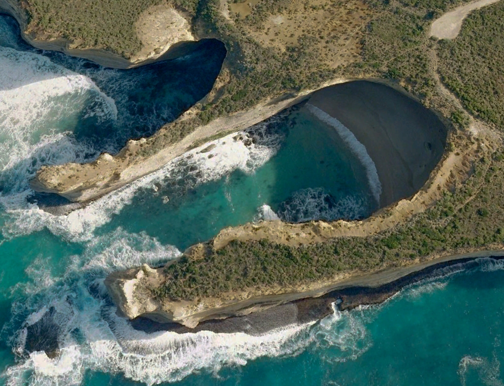
I have been visiting the coast around Port Campbell for many years, and I am still discovering new places. This is one of them. I had never even heard about this spot. As is usually the case, taking the road less travelled proved very rewarding.
I understand from Philomela Manifold’s excellent publication on ‘reading the rocks of the Great Ocean Road’, (‘Written in Stone’, self published, first edition in 2017) that the evolution of sea stacks involves a variety of forces including the waves and groundwater exploiting the natural cracks and joints in the land forms. In cliffs on the mainland these tunnels can turn into huge caves. In the case of headlands the tunnels can further erode and turn into arches which upon collapse can leave sea stacks. The evolution continues as the sea stacks steadily erode, eventually leaving permanent rock platforms on the seabed. The combination of limestone and harder rock layers in the area accounts for the differential erosion of the landscape which results in many of the spectacular coastal landforms. One of the ‘Twelve’ Apostles collapsed in 2005. There were already considerably less than 12 stacks in the vicinity. In 1990 a famous arch between Peterborough and Port Campbell on this coast (London Bridge) collapsed, stranding two tourists who suddenly found themselves on an isolated brand new sea stack. If ever a couple was made indelibly aware that ‘geological time includes now’, it was that couple. They were rescued by helicopter. Surely the thinner of the two headlands in the above aerial photo is nearing the time of its transformation into a new sea stack. This is the view looking west from a vantage point at the end of a rough looking dirt track leading off the GOR, with no signs indicating it led anywhere worth going. An invitation I could not refuse.
This was the view looking south from the end of the track. The slender headland shown in the aerial photo above is on the right in both images. There was a sandy beach at the head of this cove, and clear aquamarine water in the tiny bay with a seabed of reefs and kelp beds.
NOTE: I would not take children out on the narrow headland. With care and common sense, it can be walked. But in my view it remains a dangerous place with an element of risk not present at other attractions along this coast. It can be safely and satisfyingly viewed without walking out on this headland. Warning signs in the area warn of the dangers and risks here.
These images show the precarious state (at least to my uneducated eye) of the two headlands jutting out into the ocean at this location.
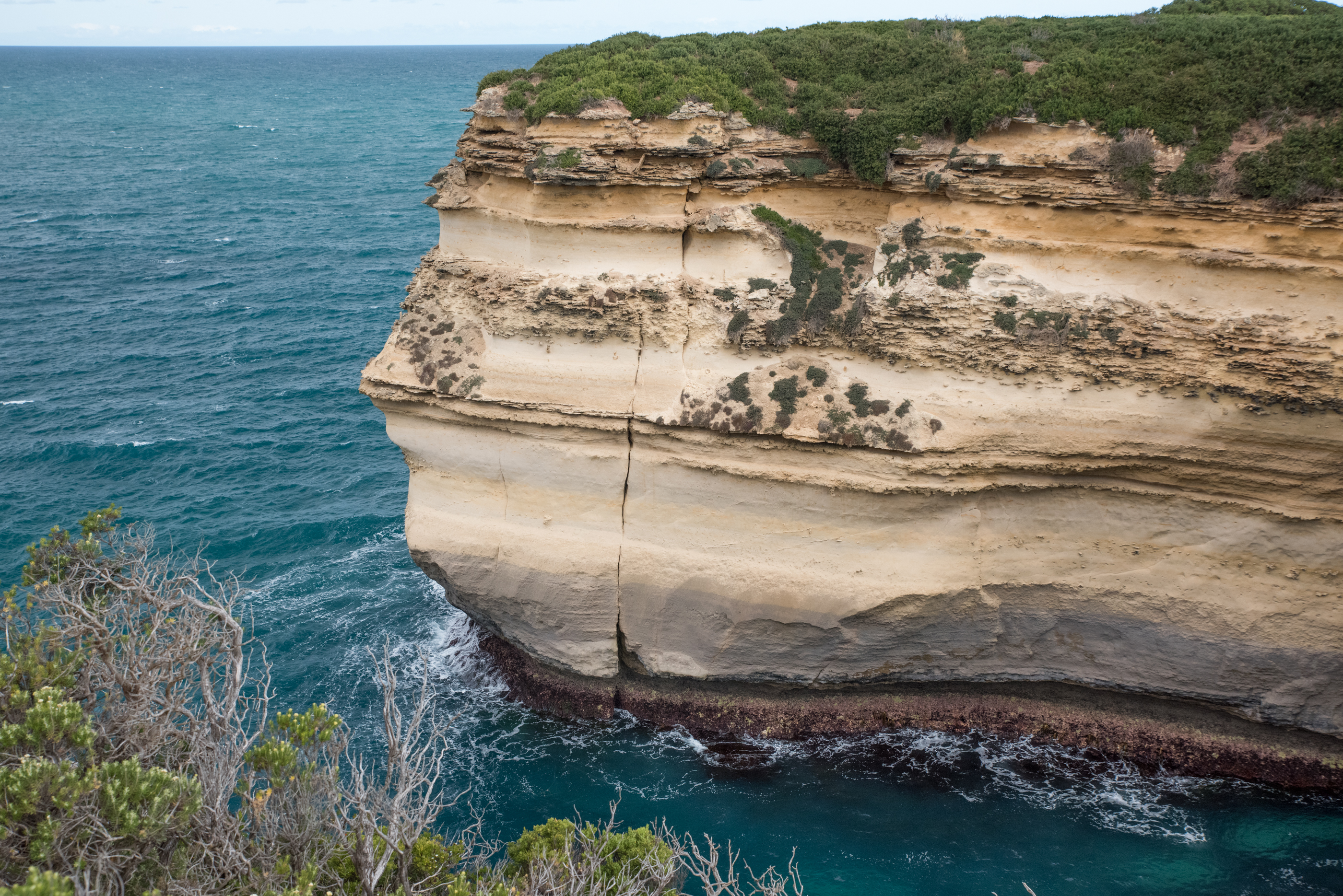
The first two photos show the headland (and a closeup of it) immediately to the east of the narrow headland. Apart from the various layers eroding at different rates due to their different composition, there are two major cracks visible near the top of this headland. Perhaps it would not be an entirely foolish guess that at some point the top third or more of this cliff will fall into the sea, leaving a clean new face exposed to the elements for slower processes to continue working on. The fourth photo below under the heading ‘Muttonbird Island’ shows a cliff on a headland where just such a separation has occurred (albeit in the lower rather than the upper section of the cliff face on the headland). It appears to have created something of a small reef directly where it fell.
The other two photos show the western edge of the cliff edge on the western side of the slender headland. At this height, the rock and limestone is only being eroded by wind and rain. Once again, the harder layers survive and the limestone is first to go. The small fragment extending out in the bottom image was as it looks – almost paper thin. It looked as though it would snap as easily as a thin dry biscuit. There are no footholds or handholds on these worn fragments, and some appear to be barely holding their own weight.
Lizzie (who knows no fear of heights), triumphantly atop the very end of the slender headland. What was she thinking!? I had been walking ahead of her and I stopped as I reached the decision that about where I was standing to take this photo was far enough. No need to be silly, I thought. Then Liz strolled past at a good clip. Obviously exhilarated by the view left, right and straight ahead, she even broke into a bit of a jog up the narrow sloping section and over the slippery shiny rounded little rocks which I saw as a sure ticket to a short flight to the ocean below.
The Caves
The route back to the mainland down the centre of the slender headland, where it begins to widen. On the right is the beach at the head of the turquoise bay shown in images above, with a smallish cave that at first glance seemed worth a further look. That is, until the cave on the left was spotted. This cave was huge. We could hear the sound of running water deep inside it somewhere. A later look at a map showed an intermittent stream in the vicinity that might have been the source. Serious erosion forces were at work on both sides of this slender headland. I just hoped it had enough structural integrity for me to get a few photos and then get back to more solid land. We were conscious that ‘geological time includes now’, and briefly discussed that notion while keeping walking at a good pace.
Looking north from the middle of the narrow headland at the beaches and caves in the gorges either side.
What a cave! I could see no easy way to get down to explore this, other than arriving by sea.
Sherbrook River
Sherbrook River beach is 1200m west of the beach in Loch Ard Gorge. It can only be reached on foot. Even on the day this photo was taken, there being no surf to speak of, there was quite a bit of water moving in and near this bay. There was a rescue tragedy here in April last year when two life savers (father and son) from Port Campbell lost their lives when they responded to the call to help a tourist who was swept out of his depth in huge seas at this location. They travelled in a rescue craft from Pt Campbell to the Sherbrook Beach area and it capsized in the huge breaking waves near the adjacent cliffs. The tourist was winched to safety by a helicopter and survived. That story is briefly told in the post on this blog titled, ‘Two Swims West of Cape Otway’ published 8 February 2020. The paragraph on the sign headed ‘Unpatrolled Area’ appears to have been added after the sign was originally made and installed. I don’t know whether or not it was one of the responses to the tragic incident at this beach. One might have thought the first two warnings on the sign should have been enough to deter anyone from even putting a toe in the water on a day of huge swell.
Muttonbird Island
Loch Ard Gorge and Muttonbird Island
The sandy beach in the top right of the image is the Loch Ard Gorge beach. In 1878 the clipper Loch Ard was wrecked on a reef on Muttonbird Island in fog and treacherous seas. Of 17 crew and 37 passengers, only two survived. Both were washed into the gorge now know as Loch Ard Gorge. Sizeable intact parts of the Loch Ard are still on the seabed on the south western tip of Muttonbird island. It is a site which attracts scuba divers when conditions permit diving in the location. The Loch Ard was a clipper, which is a square rigged three masted sailing ship. It was 263 feet long, with a beam of 38 feet and it drew 22 feet of water. It weighted 1693 tons and its masts were around 150 feet high.
Loch Ard Gorge with the ocean in repose. If you were to swim out between these two headlands and head to the right, you would be on direct track for the north eastern corner of Muttonbird Island. Loch Ard Gorge under the stars at dusk.This photo was taken from the Muttonbird Island viewing area. The headland with the reef in from of it and the obviously truncated point (due to erosion) is the western headland of the Loch Ard Gorge bay.
This small cove which is immediately adjacent to Loch Ard Gorge (on the western side), has a large cave at its northernmost point, and an interesting door shaped cavity nearer the seaward point. I’d love to investigate this area on the right day in a small boat. The second of these photos shows the fracture surface left after the southern tip of the headland completely broke away in a moment or two, rather than eroding away gradually.
If you swam out from Loch Ard Gorge and turned right at the western headland, you would see the eastern tip of Muttonbird Island (partially visible on the right of the image) directly ahead.
Left: a fracture line on the eastern tip of Muttonbird Island, indicating a possible eventual point of separation of this point into the sea below. The debris would probably form a reef if the water was not too deep at that location.
Right: On the northern end of Muttonbird Island there is a tunnel I never knew about until the day I took this photo. There is every indication that it gives clear passage (for a swimmer at least) through to the small circular bay on the other side of the arch. Plainly the route of choice if swimming around this island.
The green water passage under the arch to a small bay. This is a very inviting sight for any ocean swimmer. I hope some time to get a water level photo of this arch and channel. That would be a swim to remember.
The short-tailed shearwater (aka the muttonbird)
The remarkable annual migration of the muttonbirds is explained on this noticeboard. They are clearly superior gliders, long distance flyers and remarkable navigators. But I cannot leave unchallenged the notion of anything that flies gaining height over the ocean by merely ‘banking into the wind.’ When low flying near e.g. waves, there is no doubt they could sustain flight without much movement of their wings by using the rising air on the windward side of waves. But only a small amount of height could be gained in such rising air.
An ocean swim around Muttonbird Island?
After the wonderful and memorable Boat Bay ocean swim (described in a post in this blog published 8 February 2020, and titled, ‘Two Ocean Swims West of Cape Otway’), there was talk of the possibility of the next such swim being around Muttonbird Island, starting and finishing on the beach in Loch Ard Gorge. Most disappointingly, it never eventuated. But I have not been able to let go of the idea of such a swim. The route I would suggest would involve swimming through the channel under the arch on the northern tip of the island, into the little bay as shown on the route line above. The distance of the line shown is 1850m. Obviously there are a lot of days in the year when ocean and weather conditions would not permit such a swim to be done safely. But I reckon autumn would have more of its fair share of good days than the other seasons. IRB and paddle board support would of course be essential. Are there any readers of this post who would be interested in doing such a swim? If the swim did take place, I would definitely want that pipe band on the beach in the gorge piping us into the water – just like they did at the Boat Bay swim. As an alternative to an organised and advertised swim open to the public, a smaller group may be easier to mobilise at short notice when the weather and sea conditions were suitable…. Public or private swim, either way I am confident it would be a wonderful adventure and a truly memorable swim.